This piece was written by Kelly Page and Sophia Richter from the Maine Maritime Museum as part of Interco(a)stal: Reading Between the Ribs of Maine’s Maritime History. To reach Kelly and Sophia, contact: library@maritimeme.org
“Sturgeon are people, very much like us. You must be careful which ones you eat, and make offerings and feasts when you catch them. They’re one of our Indian foods. […] Everything must be done the right way.”
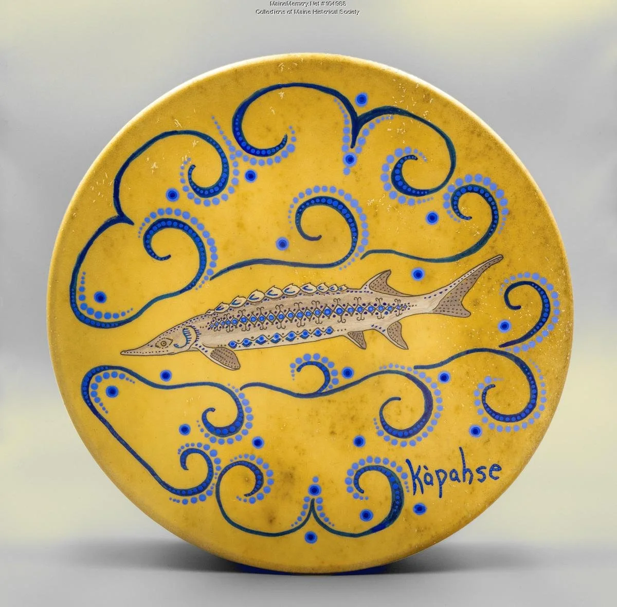
Leather stretched over a wooden frame, with the side-view of an Atlantic sturgeon framed by distinct spiraling linework painted in acrylic.
The drum is dedicated with the Penobscot word “kapahsé” written along the edge, to mark the "return of the [sturgeon] and the culture."
Made by James Eric Francis Sr., Penobscot, and Tribal Historian and Director of Cultural and Historic Preservation for the Penobscot Nation. [2]
Maine Maritime Museum is located along the banks of the lower Kennebec River. On a river whose very composition has been transformed by the shipbuilding, logging, and milling industries, it is easy to view the river from a human-centered lens. This narrative reconsiders the history of the river by focusing on one of its oldest inhabitants; sturgeon themselves.
The museum has three historical photographs of sturgeon in its collection, dated between 1870 and 1910. Reading these images from left to right, you might notice details that signify the passage of time between each one. The mens’ clothing and the techniques used to photograph and print the images suggest that decades passed between when the first and last photos were taken.
But what about the sturgeon in these photos; do they add to our sense of place and the passage of time? Each sturgeon is over six feet long, appears to be the same species—Atlantic Sturgeon—and has clearly been removed from the water by humans. Without knowing the history of sturgeon populations in the Kennebec, we glean very little from these photographs about human-sturgeon relations. By cross-referencing the three images with local Maine newspapers and other sources created around the same time, we are able to contextualize these otherwise unmarked photos.
I.
Sturgeon are some of our planet's elders. These sturgeon elders have been swimming along their migratory routes between the ocean and the rivers for around 160 million years.[3]
When the sturgeon travel up the rivers, it is to find suitable substrate (the river bottom) and water quality to lay their eggs, millions at a time. Despite the distance and time away from these rivers, the natal freshwater habitats imprint unique signatures on sturgeon, enabling them to navigate back to the exact river systems to spawn in which they themselves were born. Even so, evidence of genetic cross-pollination between sturgeon from distinct river systems also suggests that some of these sturgeon will choose to find new spawning grounds, serving as a "key ecological strategy for Atlantic sturgeon over evolutionary timescales".[4]
Thus, sturgeon can be thought of as living within distinct communities distinguished by their natal rivers.[5] What happens along their banks, in their waters, and to their beds can have a ripple effect across this watery network.[6] Additionally, because of these distinct communities, and their slow growth rates, sturgeon population dynamics are quite difficult for scientists to study,[7] making it challenging to tell complex stories about human activity along the Kennebec River and their impact on sturgeon.
Sturgeon life history reframes our sense of place along the Kennebec River, not as an insulated ribbon of water that begins at Moosehead Lake and ends at Popham beach. Rather, Kennebec is one porous artery within an aqueous womb blanketing much of Maine. To them, the river is death and rebirth. They remind us that the dichotomy between river and ocean, fresh and saltwater, land and sea, is blurred by the nutrients passed between terrestrial and watery life. By letting the sturgeon's life history give shape to the narrative, we can see how settler and indigenous ways of knowing, as well as how entanglements of local and global histories are all essential components.
II.
The oldest of the three photographs captures a scene somewhere along the Kennebec riverbank on which a multigenerational group of well-dressed men and boys pose behind the beached body of a sturgeon. Frank A. Morrill puts the scene in the mid 1870s.
Sources from this period suggest that businesses from New York were arriving in Maine in the mid-1870s to pay Maine fishermen to catch sturgeon for out-of-state markets. In July 1875, the Kennebec Journal announced the arrival in Augusta -- for the second year in a row -- of the "famous sturgeon men," German-speaking businessmen from the "firm of Weinacht & Rainecke, of New York".[8] This was noted by some Mainers as a "revival of an old business, viz. sturgeon fisheries."[9] Another voice from the newspapers recalls that during the 1870s the sturgeon fishery "was again revived, the fish having again struck their old haunts in the vicinity of Merrymeeting Bay."[10]
An "old business" indeed. The Kennebec sturgeon have been fished for sustenance by – and culturally important to – Wabanaki peoples since time immemorial. Wabanaki place names are a testament to this long history. For example, kapahsékhαhti, commonly written on settler maps as cobbosseecontee stream, means "sturgeon-gathering place" in Penobscot.[11] It is a place name not just for a specific section of water where Wabanaki people could hunt these great fish; it also conveys an understanding about the distinct ecological importance of this area to sturgeon across deep time.[12]
By the 1600s, sturgeon also became an important source of food that fueled colonization and supported coastal Maine settler communities.[13] Settler newspapers like the Portland Daily Press published articles in the 1880s about their understanding of Wabanaki place names where sturgeon were caught.[14] Many of these sources produced during the 1880s are riddled with settler mythologies like expeditions of discovery and racial superiority. The past-tense is used to describe Wabanaki presence in Maine, highlighting the cultural genocide and violence of memory these newspapers reproduce.[15] Small Point harbor; Augusta; and Fort Halifax are some names marking where 17th and 18th century settlers caught the sturgeon.[16] These words are memorials to the presence of sturgeon in these waters for as long as people have remembered their place names.
Sources suggest that during the turn of the 19th century fishers set up a camp on a small island near the outlet of Merrymeeting Bay to hunt sturgeon. They would harvest, pickle, and pack the sturgeon meat and ship it to the West Indies.[17] Even as sturgeon migrated to the southern waters of Florida, their preserved meat was being shipped from their natal rivers right back to those warmer climes to fuel empire.
As Maine's own timber and textile industries began to rapidly expand in the 1830s, these markets competed with the fisheries for control of the rivers. One of the first major infrastructure projects to suggest this transition was created by the Kennebec Mill Dam Association, founded in 1834. Despite numerous petitions from communities along the Kennebec river, the association built what would later be known as the Edwards Dam.[18] Collections at the Maine State Archive evidence the voices of these protesters who bore witness to the immediate impact the dam had on the migratory populations of sturgeon, salmon, shad, and alewives.[19] Between 1837 and 1875, the Kennebec sturgeon were choked off from many of their natal river beds, forced into a smaller habitat and thus subject to intensive fishing in those locations.
Comparing Bath maps from 1835 and 1878, we get a stark look at how sturgeon habitat was changed during this period by human development.[20] Bath during the 1830s was a lattice-work of bridges, wharves, and walls extending over the Kennebec's tidal river banks. Flash forward to the 1870 map, and later the 1878 maps, and you see that those shaded sections were infilled, hardened, and built over.
While variations in fishing method, demand, and recordkeeping over time make it difficult to tease out the scale of historic commercial extraction, the rhythmic rise and fall of fishing firms give the impression that sturgeon were sensitive to pressure. In an 1887 study of the river fisheries, the U.S. Fish Commission reported that the New York export market for sturgeon in Maine lasted less than a decade before "the business was relinquished to local fishermen" in the early 1880s once the "sturgeon again became scarce."[21]
Between the 1850s and 1930s, Bath's primary industry was shipbuilding. This changed the very coastline of the Kennebec and thus the sturgeon's habitat. Bark, wood shavings, and sunken logs from trees in Maine as well as from the South leached tannins into the water, changing its chemical composition.[22] Additionally, in order for the ships traveling out to sea to clear the river bed, there would have been the need to dredge sections of the river, removing important feeding habitat.[23]
This is the ecological and human context for the second sturgeon photograph in the museum's collection. The second sturgeon photograph here was taken in Hallowell in April of 1896. According to the Lewiston Sun-Journal, this massive eleven foot sturgeon, weighing just under 500 pounds, was caught by Chester F. Winslow and his brother while they were fishing for shad. So rare was this occasion that this sturgeon was studied and put on display. Journalist George Singer noted that "in former years sturgeon often came up the Kennebec to Augusta and could be seen any summer day jumping out of the water," whereas now it had "become rare".[24] Singer recalls that sturgeons' presence was common enough back in the day that "they used to bother the shad nets and... fishermen, infuriated by their damaged nets, would throw the unfortunate fish alive into fires on the shores."[25]
The third and last sturgeon photograph is of Kenneth Edgecombe of Bath. He stands on a wooden pier in front of a wood-paneled shed. A review of newspapers referencing Kenneth suggests that this photograph was likely taken around 1910. Kenneth was thus among a "considerable fleet of power boats and other fishing crafts [to] strew twinkling lights on the Kennebec as they [drifted with their nets] for sturgeon and shad" at night.[26]
This last photograph gives us pause. During the turn of the century, sturgeon fisheries across North America were collapsing under the pressure of the Black Gold Rush for sturgeon roe. And yet, on the Kennebec River, news accounts optimistically claimed that "just now the fish are greatly on the increase,"[27] and the "sturgeon fishermen are doing a good business."[28] In a retrospective piece published in the Bath Daily Times Record in 1940, the author looks back to this time when fishers like Horace Mitchell could make a living "taking shad, sturgeon, and smelts from the Kennebec River [...] trapping muskrats and minks along its banks, and guiding duck hunters on the Bay."[29]
These witness accounts of the seeming restoration stand in contrast to others of the same period. In 1909, around the time the Wyoming was to be launched, "Bath men" recalled their childhood spent "on a wharf watching sturgeon jump" and mourned the loss. Another voice coming from the Brunswick Record writes in elegy that the sturgeon "have gone - those big fellows - but there are still many small sturgeon in the rivers."[30]
Within these sources, at every optimistic pronouncement of restoration, there is the subtext of precarity and long-term trends towards population decline. In the background, dams continued to be built, such as the Wyman dam in 1931 which transformed the very shape of the river.[31] By the 1950s, the enemy of the sturgeon lighted on paper mills and untreated waste pollution being dumped into the river.[32] On the eve of 1972, Bath Iron Works was preparing another major riverbank transformation. This can be seen in the proposal painted by James Stilphen in 1969 for an in-filled dry dock to replace the old wharves.[33] It would have been a major project, further reducing sturgeon habitat. But it didn't happen.
The Clean Water Act, pushed forward by Maine's legislator U.S. Senator Edmund Muskie, gave immediate protections to the Atlantic and Shortnose sturgeon populations in Maine's rivers. Where the infilled drydock at BIW would have disrupted the Kennebec riverbed, it now floats above the surface. Where dams once blocked the very rhythm of the Kennebec and its tributaries, they are slowly being removed. The Edwards dam, removed in 1999, was the first hydroelectric dam to be removed in the country, serving as a testing ground for future dam removal and river habitat restoration. Where once these industrial "improvement" projects had absolute control over the Kennebec, the tides of power have shifted, if only a little, to include non-human and non-extractive values.
III.
These three images open up a dialog that extends far beyond them in multiple directions and scales. There are linear narratives of industrial development that reshaped Maine's hydrography and the ecosystems within it. There is a narrative of contested memory within settler-produced sources, whose arc was most apparent during the late 19th century. While this essay does not balance out the narrative, it does suggest the need for "reading along the bias grain" of these sources to understand how they impact our understanding of the past.[34] In what ways might this story of sturgeon also be a story of Wabanaki dispossession?[35]
In addition to these complex human dimensions of the story, this essay has identified the friction between human and non-human histories. While we can extrapolate the possible ecosystem impacts that human activity along the Kennebec River might have had, how are we telling those stories?
For instance, how do we make sense of the tension that emerged in the sources of the early 1900s between perceptions of sturgeon population recovery and long-term trends of decline? In equal measure, we find the optimistic accounts of commercial sturgeon fishing activity and the qualitative evidence that sturgeon populations were lower than in previous years. Were these people reliable narrators of their own experience?
Among historians who have explored this question, historian of New England's fisheries, Daniel Vickers, applied ecologist Daniel Pauly's term shifting baseline syndrome to explain this. It is a bias that describes "the proclivity to forget that all ecological phenomena have a prehistory - that the baseline from which a rising or falling population is measured was, in turn, the endpoint of earlier developments".[36] Building on this, Loren McClenachan et al. shows how historians and scientists can tap into a longer sense of time through fisheries logbooks, oral histories, and photograph collections, to understand pre-1950s marine species histories to fill in gaps before modern survey methods were developed.[37] Here, we can include indigenous place names, newspapers, and material culture to the list of rich source material.
Taking a step back, the three photographs in the museum's collection raise questions about how we can tell stories about sturgeon, about nonhuman life, that might correct for some of the biases that emerged in this survey. How do we expand our sense of place to include a longer sense of time? Returning to the two indigenous voices who opened this essay, it would be naive to think we must invent the wheel. In what ways do Wabanaki cultures already articulate meaning in this way, and what does it look like to meaningfully bridge these ontological and historical divides?
Footnotes
[1] Winona LaDuke, The Winona LaDuke reader: a collection of essential writings. In Return of the Sturgeon: Namewag Bi-Azhegiiwewaad, (Beverly, MA: Voyageur Press, 2002): 36.
[2] James Eric Francis Jr., “James E. Francis kapahse (sturgeon) drum, Indian Island, 2019,” Leather, acrylic. Indian Island, Penobscot County, ME. Digitally viewed: https://www.mainememory.net/record/104988/image/104988
[3] Lily C. Hughes et al. “Comprehensive phylogeny of ray-finned fishes (Actinopterygii) based on transcriptomic and genomic data,” Proceedings of the National Academy of Sciences, Vol. 115, No. 24 (June 2018): 6249 - 6254.
[4] Natalia A. S. Przelomska, et al., “Archaeogenomic analysis of Chesapeake Atlantic sturgeon illustrates shaping of its populations in recovery from severe overexploitation,” Proceedings B Royal Society 291 (October 2024). https://doi.org/10.1098/rspb.2024.1145
[5] Gail S. Wippelhauser, et al., “Movements of Atlantic Sturgeon of the Gulf of Maine Inside and Outside of the Geographically Defined Distinct Population Segment,” Marine and Coastal Fisheries, Vol. 9, issue 1 (January 2017): 93-107. https://doi.org/10.1080/19425120.2016.1271845
[6] David C. Kazyak, et al., “Stock composition of Atlantic sturgeon (Acipenser oxyrinchus oxyrinchus) encountered in marine and estuarine environments on the U.S. Atlantic Coast,” Conservation Genetics Vol. 22, (April 2021): 767-781. https://doi.org/10.1007/s10592-021-01361-2
[7] John Waldman, et al., “Contemporary and historical effective population sizes of Atlantic sturgeon Acipenser oxyrinchus oxyrinchus,” Conservation Genetics, Vol. 20, (November 2018): 167-184. https://doi.org/10.1007/s10592-018-1121-4
[8] “Farmingdale Locals – The Sturgeon Men,” Kennebec Journal, 8 July 1875, page 3.
[9] “Sturgeon Fishing on the Kennebec an Ancient Business,” Kennebec Journal, 4 August 1875, page 3.
[10] The Lewiston Sun Journal, 8 July 1899, page 13.
[11] The Penobscot Language Map & Gazetteer, Penobscot Nation Cultural and Historic Preservation Department (2015).
[12] Fannie Hardy Eckstorm, Indian Place Names of the Penobscot Valley and the Maine Coast (University of Maine at Orono Press, 1978): 144-145.
[13] George Wheeler and Henry Wheeler, History of Brunswick, Topsham, and Harpswell, Maine, Including the Ancient Territory known as Pejepscot (Boston: Alfred Mudge & Sons, Printers, 1878): 552.
[14] Kennebec Journal, 13 April 1887, page 8.
[15] Kennebec Journal, 10 September 1885, page 3.
[16] Kennebec Journal, 4 August 1875, page 3.
[17] Charles Atkins, The River Fisheries of Maine, in: The fisheries and fishing industries of the United States, Section V, Volume 1, ed. George Brown Goode (U.S. Fish Commission, 1878): 698-699.
[18] “Edwards Dam,” Photographic print, Maine Maritime Museum PC3 Collection, Bath, ME.
[19] Erik Reardon, Managing The River Commons: Fishing and New England's Rural Economy, 2021.
[20] “Map of Bath, 1835,”; “Map of Bath, 1870”; “South End of the City of Bath, ME and Winnegance, 1877,”; “Birds Eye View of the City of Bath, 1878,” paper and ink, Maine Maritime Museum, Bath, ME.
[21] Charles Atkins, The River Fisheries of Maine, in: The fisheries and fishing industries of the United States, Section V, Volume 1, ed. George Brown Goode (U.S. Fish Commission, 1878): 698-699.
[22] Sebastian S. Vose, “Mammoth Jame, Pishon’s Ferry, 1871-1873,” Maine Historic Preservation Commission, Stereograph, MHPC.2.142.
[23] “Dredging in Bath, ca. 1930,” Maine Maritime Museum PC3 Collection, Bath, ME.
[24] George Singer, “The Armored Sturgeon,” Lewiston Sun Journal, 11 July 1896, page 3.
[25] George Singer, “The Armored Sturgeon,” Lewiston Sun Journal, 11 July 1896, page 3.
[26] “Tustle with Sturgeon,” Lewiston Sun Journal, 14 May 1910, page 8.
[27] “Valuable Sturgeon: Large Numbers Seen in Cathance River,” Brunswick Record, 8 September 1905, page 2.
[28] “Sturgeon Fishing: Good Business is being Done on the Lower Kennebec,” Morning Sentinel, 22 July 1904, page 3.
[29] ”Old Sturgeon Fishing Days Recalled by Veteran Who Made Some Big Catches,” Bath Daily Times Record, 22 October 1940, page 5.
[30] “Shad and Sturgeon: Text of the Bill Introduced for Their Protection,” Brunswick Record, 25 January 1907, page 4.
[31] Bicknell Manufacturing Company Photographer, “Wyman Lake, 1931-1954,” Maine Historic Preservation Commission, Photographic Print, MHPC.PC.2481; Bicknell Manufacturing Company Photographer, “The New Wyman Dam, 1931-1954,” Maine Historic Preservation Commission, Photographic Print, MHPC.PC.2476.
[32] “Dead Sturgeon Found in Merrymeeting Bay Area,” Kennebec Journal 26 June 1957, page 1.
[33] James Edwin Stilphen, “Conceptual watercolor painting of BIW yard, 1969,” painting, Maine Maritime Museum, 85.071.
[34] Marisa Fuentes, Dispossessed Lives: Enslaved Women, Violence, and the Archive. (Philadelphia: University of Pennsylvania Press, 2016).
[35] Patrick Hayes et al., “Ecological legacy of Indigenous dispossession: disruption of ancestral sea gardens by commercial clam fisheries in British Columbia, 1882–1985,” Philosophical Transitions B Royal Society, 380 (July 2025): 1-16. https://doi.org/10.1098/rstb.2024.0277
[36] Daniel Vickers, “Those Dammed Shad: Would the River Fisheries of New England Have Survived in the Absence of Industrialization?” The William and Mary Quarterly, Vol. 61, no. 4 (October 2004): 685; Daniel Pauly, "Anecdotes and the Shifting Baseline Syndrome of Fisheries," Trends in Ecology and Evolution, Vol. 10 (I995): 430.
[37] Loren McClenachan, Francesco Ferretti, and Julia K. Baum, “From archives to conservation: why historical data are needed to set baselines for marine animals and ecosystems,” Conservation Letters, Vol. 5, Issue 5 (May 2012): 349-359. https://doi.org/10.1111/j.1755-263X.2012.00253.x
About the Author(s)
Kelly Page, Curator of Collections, Maine Maritime Museum

Kelly Page is the Curator of Collections at Maine Maritime Museum, where she has served in various roles since joining the institution, including Library Assistant, Registrar, and Collections & Library Services Manager. In her current role, she oversees collections stewardship, historic preservation, and public access initiatives while contributing to interpretive research and content development across the museum's diverse exhibitions and programs. Before joining Maine Maritime Museum, Page worked at Bowdoin College's Hawthorne-Longfellow Library, the Pejepscot History Center, and the Maine State Archives. She holds a Bachelor of Arts in History and International Politics from Wheaton College in Massachusetts.
Sophia Richter, Collections Manager, Maine Maritime Museum

Sophia Richter is Collections Manager at the Maine Maritime Museum, where she oversees the stewardship, preservation, and accessibility of the museum's collections in support of research, exhibitions, and public engagement. Her interests lie at the intersection of history, archives, public memory, and community engagement. Before joining the museum, Sophia completed an M.A. at Concordia University, where her research focused on environmental history, fisheries, and deindustrialization. She has published on the political economy of fisheries and environmental change and brings a collaborative, interdisciplinary approach to connecting historical collections with contemporary audiences and conversations.